By Tesfay Woldemariam, Mary Gronkiewicz and Will Anderson | World Resources Institute
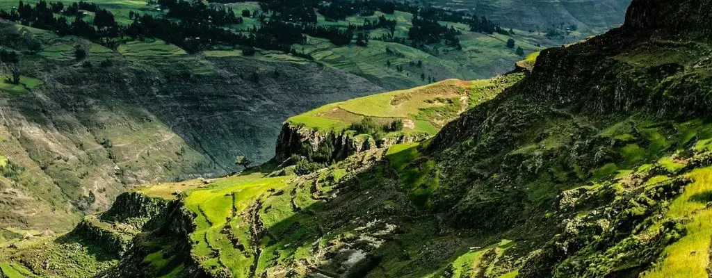
In the 1980s, Ethiopia’s Tigray region experienced famine and drought that affected millions of people. In the early 1990s, local community leaders and farmers became resolute; they would need to grow more food. To do that, they needed to trap more water in the soil. This led them on a mission to restore millions of hectares of degraded and overgrazed lands to drastically reduce the possibility of future famines.
By growing trees, terracing steep hillsides, enclosing ecologically valuable areas and embracing other techniques, communities in this region transformed over one million hectares of previously denuded land. Soil productivity, food security and water security improved in the once harsh environment, earning the region a global reputation as the gold standard for landscape restoration. Today, Ethiopia is a net exporter of food.
Energized by this success, Ethiopia joined the AFR100 Initiative in 2016, pledging to begin restoring 15 million hectares (Mha) (37 million acres) by 2030 — approximately one-sixth of its total land area — and grow 20 billion trees in the coming years. To turn that pledge into reality, Ethiopians need to combine the historical lessons from Tigray with high-quality data that can help local communities plan, implement and track progress of their efforts.
In 2018, the national Environment, Forestry, and Climate Change Commission (EFCCC) revealed that 73% of Ethiopia’s land could biophysically benefit from restoration and highlighted the 11 Mha (27 million acres) where people suffer the most from severe erosion, ecosystem degradation, food insecurity and woodfuel shortages.
This type of data is critical for the government to set priorities and develop policy, finance and budgeting decisions. Yet, the Ethiopian government can’t tell people running restoration projects how they can improve each small plot of land. This is especially important because every hectare of land has its own special qualities; a technique that restores a steep hillside may not work for a neighboring farm.
The true key to unlocking this data and achieving Ethiopia’s land restoration goals lies at the local level.
Communities and the governments in three of Ethiopia’s largest regions — Amhara, Oromia and the Southern Nations, Nationalities, and Peoples Region (SNNPR) — are especially keen to restore land. But to achieve their goals, they need quality data useful for their locality and stakeholders. While building this actionable data is a difficult task, this kind of granular and context-specific data will enable restoration practitioners to make the best possible choices for the lands in these regions.
High-Quality Local Data Accelerates Land Restoration in Ethiopia
In Amhara, the regional government, herders and farmers are working to increase forest cover from 13% to 19% and restore degraded pastureland. Doing so will address many local challenges, like soil degradation and erosion, deforestation and food insecurity. As Tigray’s neighbor, Amhara shares many socio-economic and environmental challenges, and its residents have learned from the accomplishments of their peers in Tigray.
In the past, restoring Amhara’s land led to impressive gains. In the Hulet Ij Nessie woreda (district), communitiesworked together to create no-grazing zones. Combined with tree planting and other conservation measures like terracing steep slopes, they recovered the land’s productivity in most kebeles (villages).
To replicate the achievements made in places like Hulet Ij Nessie, the Amhara government needed locally owned, actionable and granular data to identify which areas are best suited for specific types of restoration. That makes it easier for communities to know where and how they can restore land most efficiently.
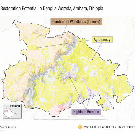
Applying the Restoration Opportunities Assessment Methodology (ROAM), the government and its partners began by agreeing how they would create a map with all of that information. Next, they convened local experts to identify the goals and challenges facing the landscapes; the right types of restoration for the social and ecological context of each landscape; and the kinds of data they needed to produce an accurate map.
The resulting charts, which the participants validated, showed where different types of tree restoration could improve the landscape across more than 10 Mha (24.7 million acres). They identified ten interventions, such as reforestation; agroforestry, which incorporates trees into farmlands; and growing commercially lucrative tree crops like incense, bamboo and gum arabic. Implementing these types of restoration will not only improve the landscape but do so in a way that reduces food insecurity, improves tree cover and boosts the local economy.
Without the lead of local experts, though, the resulting maps wouldn’t have reflected reality. During the validation workshop, a few participants argued that the total area that the researchers had said was available for reforestation seemed unrealistically high. While those areas could technically be reforested, farmers currently grew crops there. In response, the mapping experts refined the final results to exclude reforestation from some areas and found that those same farmers could use a different approach, agroforestry, to boost their crop yields while growing more trees.
After establishing this process in Amhara, WRI trained a local partner, the Water and Land Resources Centre (WLRC) at Addis Ababa University, to use the same method in Oromia and the SNNPR, which are socio-economically and physically different from Amhara. There, diverse agroforestry systems and home gardens that combine trees with perennial crops like coffee, khat and banana have a higher restoration potential than in Amhara, which has a drier climate and could benefit most from reforestation.
Overall, the assessments found that 64% of Amhara (10 Mha, or 25 million acres), 59% (17 Mha, or 42 million acres) of Oromia and 67% (6 Mha, or 15 million acres) of SNNPR could benefit from land restoration.
With locally relevant and high-quality data, local governments and leaders could plan to restore approximately 30% of Ethiopia’s total land mass in these three regions alone. And, the total combined reforestation potential from these regions is more than double Ethiopia’s entire national restoration commitment to AFR100.
The maps are not only useful for local people now, they can also be easily updated when as better-quality data becomes available, guaranteeing that communities will always be able to make important land-use decisions using the best information.
For its part, WLRC is training other experts to use the same method in new landscapes. Scaling up this method and building local technical capacity is imperative if communities and the government want to restore every priority landscape identified in the country’s national map.
Reaping the Full Benefits of Ethiopia’s Region-specific Data
Local leaders now know how much land could benefit from reforestation, agroforestry and other types of restoration. With this new information, the three regions and their stakeholders can now develop implementation plans to make Ethiopia’s 15 Mha AFR100 pledge a reality.
However, these potential maps only outline the biophysical suitability of the land for restoration. To get the most out of these maps and properly prioritize where to restore first, stakeholders must add social data on land tenure, public policies, local regulations and community priorities. Researchers should also conduct cost-benefit analyses to estimate the rate of return for each type of restoration, which can be up to $30 for every $1 spent.
In that spirit, we are working with local communities and the government in the Meket and Sodo districts of Amhara to build “landscape action plans.” These channel finance from the government and the private sector to restoration projects in areas where the return-on-investment is highest and brings the most value to communities. They can even inform budding entrepreneurs that are looking to create jobs and restore land.
The data behind the maps and action plans can also serve as a baseline that allows local people and the government to track their progress as they continue to restore more land. When funders, governments and communities embrace accurate monitoring systems and publicly report results, they can all invest with confidence.
Bringing Actionable Data to Local Communities, One Landscape at a Time
Three decades ago, Tigray made it clear: Effective large-scale restoration benefits not only the landscape, but the communities that depend on it. Now, with less than ten years left to restore 100 million ha (247 million acres) across Africa, local leaders need this kind of high-quality local data, following the example of Amhara, Oromia and SNNPR. Doing so will ensure that every dollar invested in restoring land maximizes the benefits for local people and safeguards against future risks, from climate change to famines.
