Authors: Lawrence Eric Ng’ang’a, Yigremachew Lemma, Spencer Ngoma, Alvin Adu-Asare and Diana Mawoko
Africa's natural landscapes face unprecedented challenges from deforestation, land degradation, and the adverse impacts of climate change. The African Forest Landscape Restoration Initiative (AFR100) was established to contribute towards addressing these issues, with a target of restoring 100 million hectares.
But how do you measure the progress of such an ambitious endeavor?
To ensure the successful implementation of the AFR100 Initiative, robust data is needed to plan, measure, monitor, and evaluate the progress of restoration efforts, and that is where the Tropical Tree Cover (TTC) data plays a crucial role.
What is TTC: Global Forest Watch tool displays tree extent at the ten-meter scale and tree cover at the half hectare scale to enable accurate monitoring of trees in urban areas, agricultural lands, and in open canopy and dry forest ecosystems.
How Tropical Tree Cover Data Works?
For years, much of Africa’s tree cover has been hiding in plain sight. Trees scattered across farms, drylands, and cities (known as “mosaic landscapes) are important for biodiversity and livelihoods, but traditional medium resolution satellite imageries cannot accurately detect individual trees in such environments. If an area isn’t a dense forest, most mapping systems simply overlook the trees that are there.
The emergence of Tropical Tree Cover (TTC) data in 2020 has transformed this reality. The innovative dataset maps tree cover at 10-meter resolution precision, capturing trees in agricultural lands, urban spaces, and dry forests for the first time at this spatial resolution.
By finally making these “invisible” trees visible, TTC data is giving governments, scientists, and communities a clearer picture of the trees that are growing, trees that are disappearing s , and where restoration is quietly succeeding. It’s also helping shine a light on the work of local people who protect these landscapes every day — work that has often gone unrecognized and underfunded.
Why TTC Data is Important?
Successful restoration needs good data. TTC data enhances the accuracy of tree detection across landscapes, strengthens monitoring capacities, and plays a crucial role in scaling restoration efforts by addressing critical data gaps in mosaic landscapes.
TTC contributes to:
- Improving the ability to identify priority areas where restoration can generate the highest ecological, social, and economic impacts.
- Standardizing progress tracking so countries and projects can compare results more easily.
- Fostering accountability and transparency within restoration initiatives, minimizing the risks of failing to achieve expected results within the designated time, budget, and scope.
- New opportunities to develop a tailored research agenda that generates evidence-based insights to inform restoration programs and optimize their impact on restoring ecosystem services such as carbon sequestration, biodiversity conservation, and water regulation.
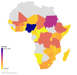
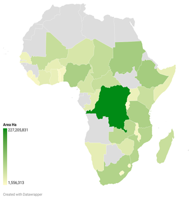
Insights from TTC Data in AFR100
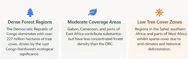
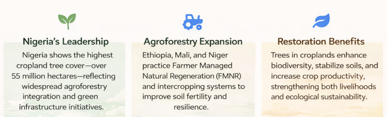
What the Data Tells Us About Africa’s Tree Cover
A Closer Look at Change on the Ground: Malawi Case study
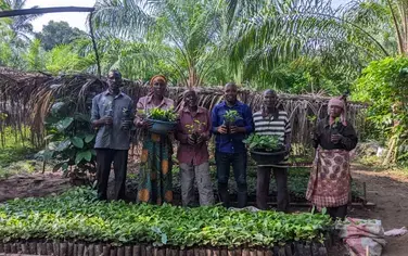
Malawi, one of AFR100’s member countries, serves as a strong case study where the National Monitoring Unit leverages TTC change data with support from the Modern Cooking for Healthy Forests (MCHF) and The Alliance for Restoration of Forest Landscapes and Ecosystems in Africa (AREECA) projects. The country has used TTC data to track restoration progress in targeted landscapes such as Perekezi forest, covering Mzimba and NkhataBay districts. It has also been used in the Mvai-Dzonzi forest, encompassing Mpira dam in Ntcheu district and to implement adaptive management strategies. Additionally, the Malawian government has utilized TTC data to guide land use policy formulation and develop forest management plans, ensuring that restoration efforts are aligned with national climate goals. Beyond policy and planning, TTC data has also played a crucial role in strengthening stakeholder engagement by providing local communities with access to reliable information. This transparency fosters trust strengthens community buy-in for restoration efforts and enhances the long-term sustainability of restoration impacts. The following two specific cases illustrate how Malawi utilizes TTC to track changes in tree cover.
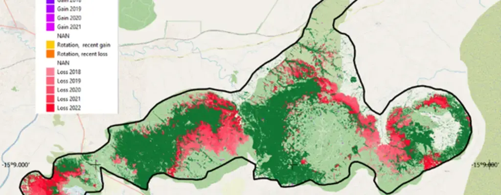
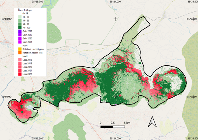
The case of Liwonde National Park
To demonstrate one use case of TTC data in comparing tree cover loss and gain in protected forests in Malawi, the case of Liwonde National Park is presented below. Using the TTC data analysis, a clear downward trend can be observed between 2017 (baseline year) and 2022, from approximately 18,000 ha to 13,000 ha, largely due to deforestation. The Government of Malawi, international and local development partners, and the community can leverage such TTC analysis to design interventions aimed at reducing deforestation.
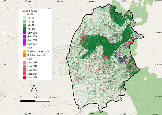
The case of TA Mzikubola
In Malawi’s Mzimba district, TTC data is helping tell a powerful story of recovery. In Traditional Authority (TA) Mzikubola, tree cover declined between 2017 and 2019, a worrying trend that signaled growing pressure on local forests.
Then there was a shift. From 2020 to 2022, TTC data shows a steady increase in tree cover, reflecting successful restoration efforts led by the Malawian government and local communities, with support from the MCHF project.
This rebound shows that restoration efforts are working. And TTC data has been essential in tracking this progress, offering clear baseline and reliable year-to-year insights.
TA Mzikubola demonstrates how TTC can serve as a practical, scalable monitoring tool for countries aiming to restore degraded forests and measure real impact over time.
Future Advancement of TTC Data for AFR100 Countries
Advances in technology present opportunities to further enhance the accuracy and applicability of data in AFR100 Countries. Key areas of development include new satellite technologies that provide higher-resolution imagery and more frequent updates, improving the ability to track tree cover changes, tree count, and tree height. AI and machine learning tools can analyze data at scale, identify trends, and identify priority areas for restoration.
Way Forward for Enhancement of Data for AFR100 Restoration Implementation