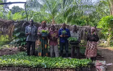
In Malawi’s Rumphi district, the Government is investing in tracking restoration progress. Credit: Thoko Chikondi/WRI
The Government of Malawi is bringing its National FLR Monitoring Framework to life in Rumphi District. The National Monitoring Framework establishes goals and key indicators to track restoration progress. Through the pilot in Rumphi District, World Resources Institute (WRI) and local partners are establishing a baseline map of vegetation in the area and tracking changes against this baseline. WRI’s Restoration Mapper (technique in development) and FAO’s Collect Earth monitoring tools are helping identify tree growth on smallholder agricultural land, pasture, and community and natural forests.
This monitoring data is an essential component of a broader landscape restoration action plan in Rumphi that will show where to restore, how to restore, who is responsible for implementation, and how the work will be financed. This data will better equip leadership in the Rumphi District Council to track progress toward local restoration goals, adaptively manage projects, and direct resources towards approaches that are working.