By Salima Mahamoudou & Bernadette Arakwiye | World Resources Institute
This article was originally published by ETFRN News.
Introduction
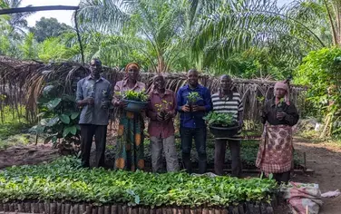
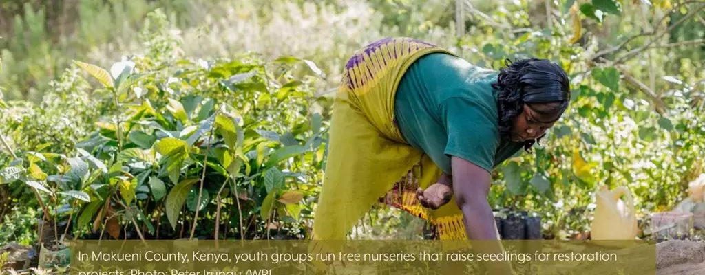
Restoring degraded land includes growing trees to transform farms, forests and pastures into more productive and resilient ecosystems. Forest and landscape restoration (FLR) is increasingly seen as a key approach to making progress in national food security strategies, poverty reduction and climate resilience (Chazdon 2017). Land restoration is not new to Africa. From Sahelian and East African drylands and savannas to Congo basin tropical forests, many communities have been restoring lands for decades to generate benefits for people and the environment. Prominent examples include farmer managed natural regeneration and assisted natural regeneration in degraded regions. Farmers have increased tree density on farms and pastureland, leading to improvements in household socio-economic conditions (Reij and Garrity 2016).
Thirty African governments have now committed to restoring deforested and degraded lands as part of global restoration initiatives, including the Bonn Challenge and the New York Declaration on Forests. Several countries, such as Malawi and Madagascar, have developed national restoration strategies, aligning stakeholders from across ministries and industries around a common framework on FLR. Successful implementation will contribute to large-scale increases in tree cover and tangible improvements in environmental conditions (Temperton et al. 2019). At the regional level, the Africa-led AFR100 initiative, under the leadership of the African Union Development Agency-New Partnership for African Development (AUDA-NEPAD), aims to restore 100 million hectares of deforested and degraded landscapes across the continent by 2030.
But to achieve these ambitious pledges, participants need to understand what has already been done, and to design and implement monitoring systems that track progress in achieving commitments and plans (Hanson et al. 2015; Cristales et al. 2020). Monitoring forest and landscape restoration is, however, not as simple as it may sound (Reytar et al. 2020). Planting and growing trees is just the beginning. It is essential to track tree survival and growth, as well as trees’ ability to store carbon and to provide nutritional, economic, biodiversity and other environmental benefits.
Challenges in monitoring restoration
Meeting restoration targets requires a holistic system to track and document progress while consistently improving management practices. Tracking restoration will help governments, local communities and NGOs show the progress made on their commitments and scale up successful projects, and positive results will inspire donors to continue investing (WRI 2020). Measuring progress in Africa can also spotlight farmers and local champions who have restored their land through grassroots approaches. But their successes can be replicated only if practitioners and decision makers understand land restoration’s impacts on people and the environment.
With tools such as the Restoration Opportunity Assessment Methodology (ROAM) and the Rapid Restoration Diagnostic (RRD), many African countries have accurately and efficiently mapped trees and assessed opportunities, both nationally and within individual landscapes. As a result, AFR100 restoration commitments have significantly grown and gained momentum (Akinnifesi 2018). However, before starting restoration work, countries must assess the current state of their landscapes to establish a baseline for planning and monitoring progress. Unfortunately, most existing forest monitoring systems were tailored to tracking deforestation, not restoration. The remote sensing techniques that they use fail to detect small or scattered trees, or they assess only tree cover and fail to include the benefits that those trees provide. Most importantly, these systems are often too expensive to operate at scale (Reytar et al. 2020).
Several conventional monitoring frameworks and datasets are relevant to forest and landscape restoration in Africa. They include the Food and Agriculture Organization’s Forest Resources Assessment and the IUCN-led Restoration Barometer, both of which compile self-reported statistics from government sources. Freely accessible satellite imagery has also increased the capacity of some African countries to monitor changes in land use (Sloan and Sayer 2015). However, these datasets suffer from a lack of consistency and completeness across entire countries and time spans (Brink and Eva 2009). Furthermore, within countries, data for monitoring restoration is often fragmented and scattered throughout different institutions and ministries, which makes it difficult to comprehensively assess progress.
What is required?
The World Resources Institute’s extensive work in countries such as Malawi, which built the first framework in Africa for monitoring a national restoration plan, has made it clear that there is no one-sizefits-all approach (Government of Malawi 2018). Plans to implement large-scale restoration have highlighted gaps in the systems that track progress. First, forest and landscape restoration inherently has a long time horizon; it can take years to observe substantial changes on the ground. Second, restoration objectives can vary widely because they target a range of ecosystems or land uses, they include tree-based and non-tree-based techniques, and they rely on diverse approaches that affect the landscape in different ways. The nature of FLR and its diversity of approaches thus require adaptable monitoring frameworks (WRI 2020).
Effective monitoring systems must be tailored to this complexity. They must also be suited to each country and project’s specific needs, contexts and ecosystems (while taking a consistent approach). In addition, measuring progress in tree growth — from seedlings to saplings and from young trees to mature trees — requires monitoring systems that incorporate long-term data. It is thus important to determine what can be detected within the proposed timeframe of an initiative and to select appropriate indicators to monitor (Cristales et al. 2020). Monitoring should always focus on measuring progress toward the specific goals that restoration efforts plan to achieve. In sum, there should be one vision for monitoring effectively, but a variety of approaches at three scales: globally across Africa,
within countries and landscapes, and for individual projects (WRI 2020).
Existing tools
The AFR100 Initiative could fail to achieve progress or impacts if it does not have flexible monitoring systems. Monitoring systems must be efficient and transparent, must incorporate lessons learned from successes and failures, and must document progress in a credible and compelling way. They also need to attract financial support at a scale consistent with their ambitions. With those criteria in mind, the following text describes the most efficient tools and methodologies to guide African governments, project developers, and entrepreneurs as they build systems to measure progress. Table 1 summarizes these tools.
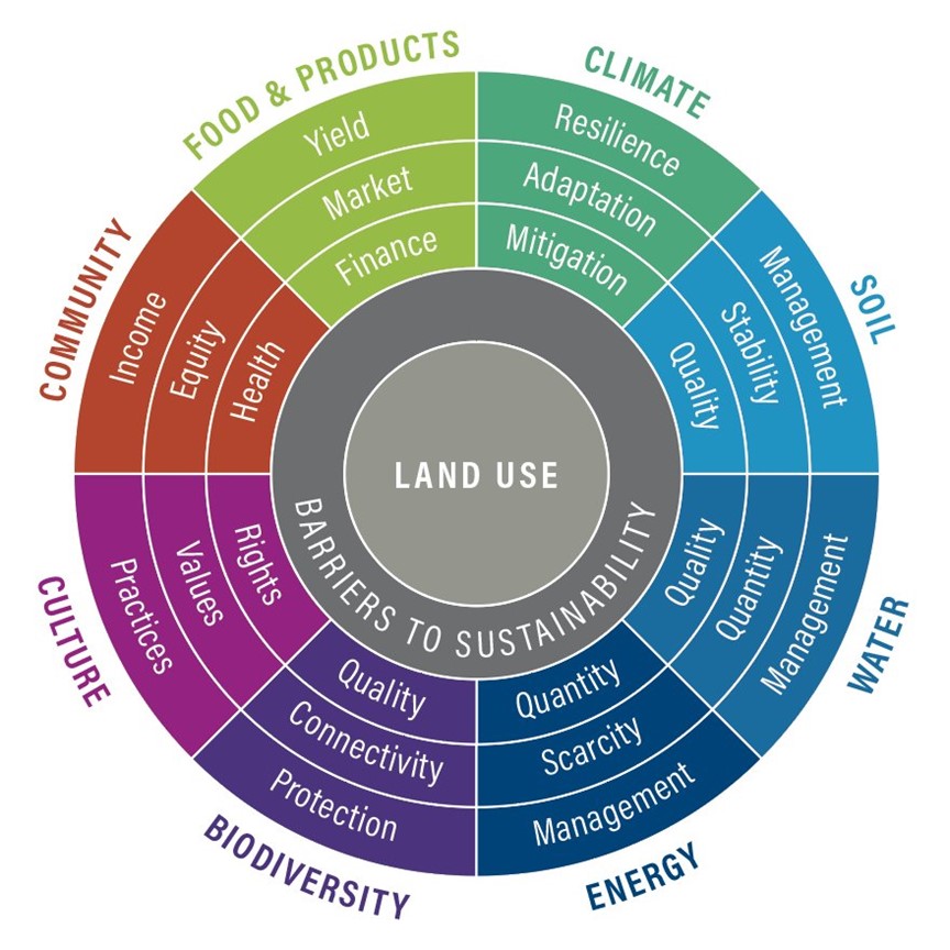
FAO and the World Resources Institute created this flexible guide. It helps governments and organizations that are restoring land to design a comprehensive system that allows them to make informed decisions and measure progress (Buckingham et al. 2019). It helps practitioners understand the current state of the landscape being restored, identify what they want to achieve, choose the indicators they need to prove success, and develop an actionable strategy for tracking progress (Figure 1). Several countries in Africa, including Ethiopia, Kenya and Malawi, have used this methodology.
Figure 1. The Road to Restoration goal wheel and relevant indicators. Source: Buckingham et al. (2019)
Road to Restoration
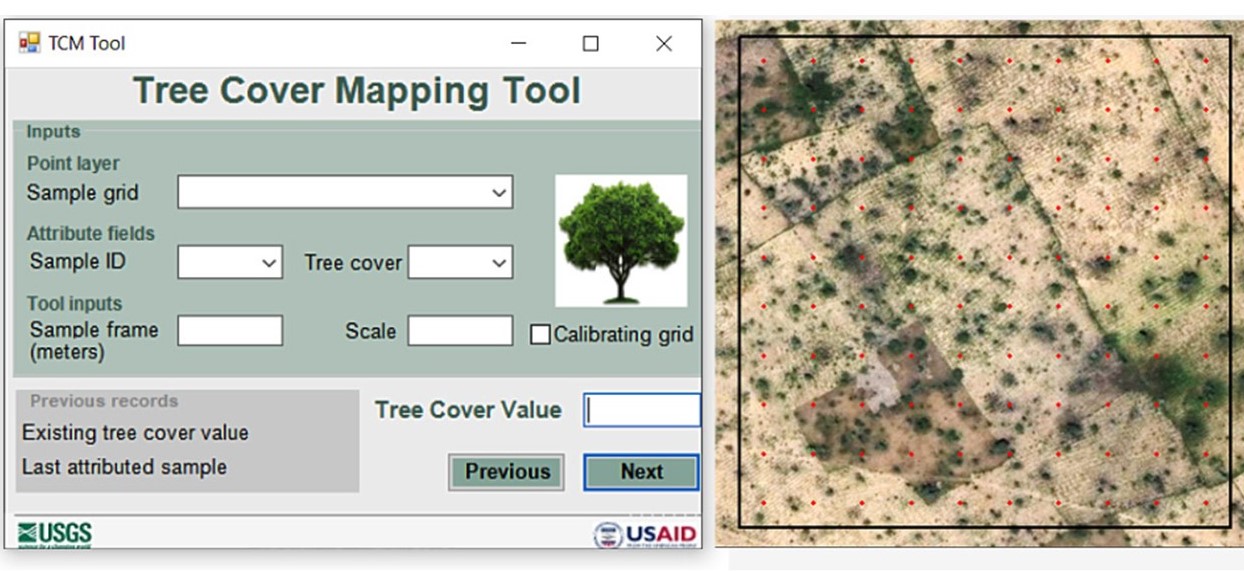
This was developed by the United States Geological Survey to map tree cover density at large scales by visually interpreting high-resolution satellite imagery (Cotillon and Mathis 2016). It uses a grid-based sampling approach to produce tree cover maps (Figure 2). It is particularly effective at measuring tree cover density outside forests, such as in agroforestry systems. The tool has been used to map on-farm tree cover in Burkina Faso, Malawi and Niger, and could be used throughout Africa’s drylands. The tool can be downloaded as an add-on to the ESRI ArcMap Geographic Information System interface.
Figure 2. The Tree Cover Mapping tool interface, showing a sample plot. Source: modified [by G. Tappan] from graphic in Cotillon and Mathis (2016)
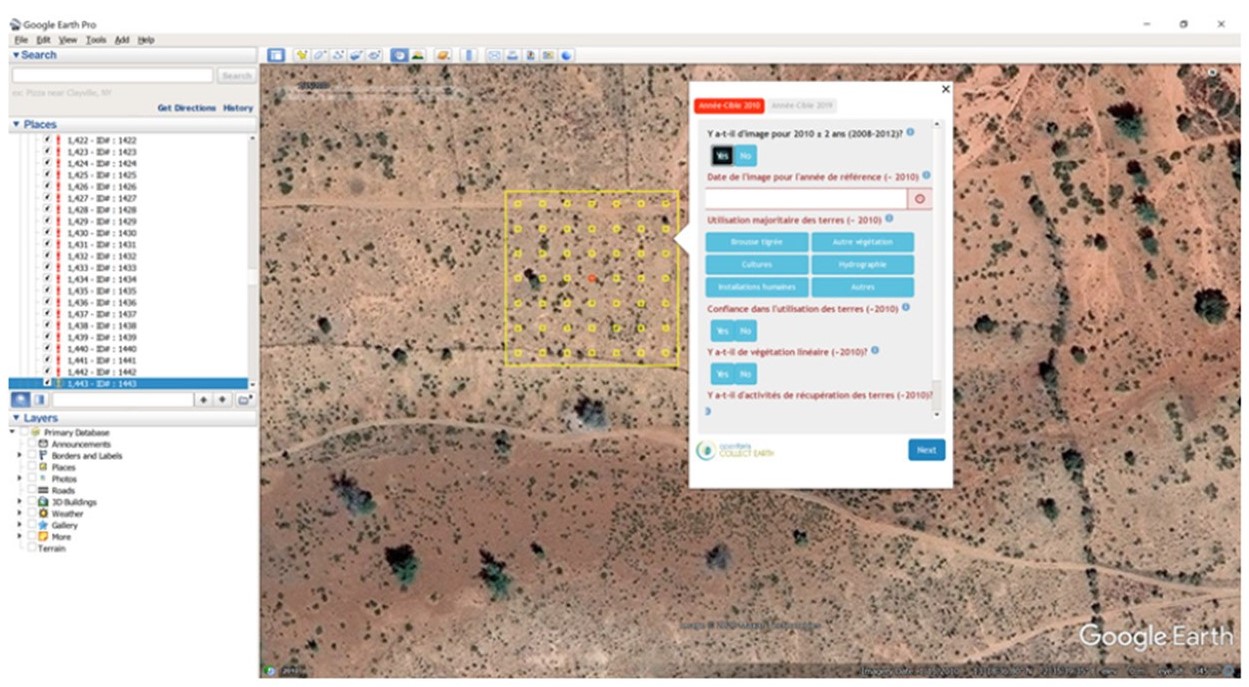
This user-friendly and participatory mapping and monitoring tool is open source and Java based. It draws on a selection of other software to facilitate data collection. In conjunction with Google Earth, Bing Maps and the Google Earth Engine, it allows users to analyse high- and very-high-resolution satellite imagery in order to collect broad data on the number of trees, tree cover density, infrastructure and land use. It shows changes in a time-efficient and cost-effective way (Figure 3). In a collaborative process called a Mapathon, local experts visually identify features in the landscape, collectively producing high-quality data that they own. To date, Collect Earth has produced statistics on tree cover and land-use changes in many African countries, including Cameroon, Ethiopia, Kenya, Malawi, Niger and Rwanda.
Collect Earth Online is the web-based version of the tool; it eliminates the need for software installation and data management, and consistently locates, interprets and labels reference data plots for classifying and monitoring changes in land cover and land use.
Figure 3. The Collect Earth monitoring tool interface, showing a sample grid. Source: WRI (2020)
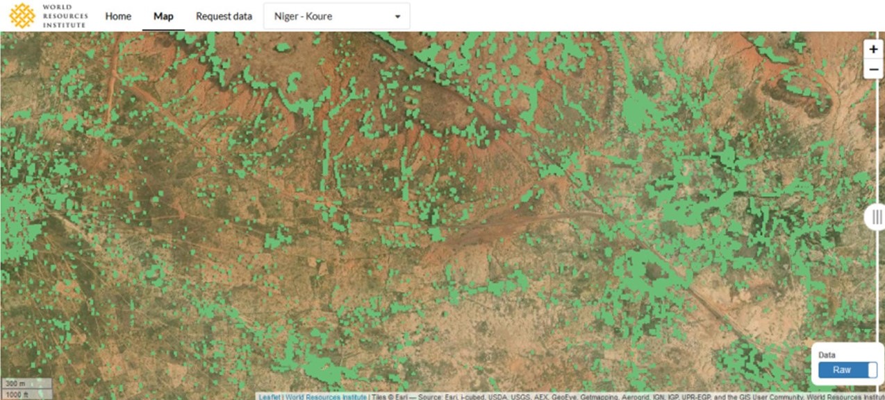
World Resources Institute (WRI), the University of Copenhagen and NASA are exploring new techniques that use artificial intelligence and apply machine learning to analyze raw satellite data from across the Sahel and other African landscapes (Brandt and Stolle 2020). The goal is to build accurate and comprehensive maps of millions of trees, which have rarely been considered in official statistics, plans and models (Figure 4). So far, WRI has analysed more than 30 landscapes of 10,000 hectares each with this technique. This approach could be improved to determine which tree species are present in the landscape, allowing the development of a more accurate and comprehensive regional database for land restoration in Africa (Miyoshi et al. 2020).
Figure 4. The Restoration Mapper interface, showing tree cover in a part of the Sahel. Source: Brandt and Stolle (2020).
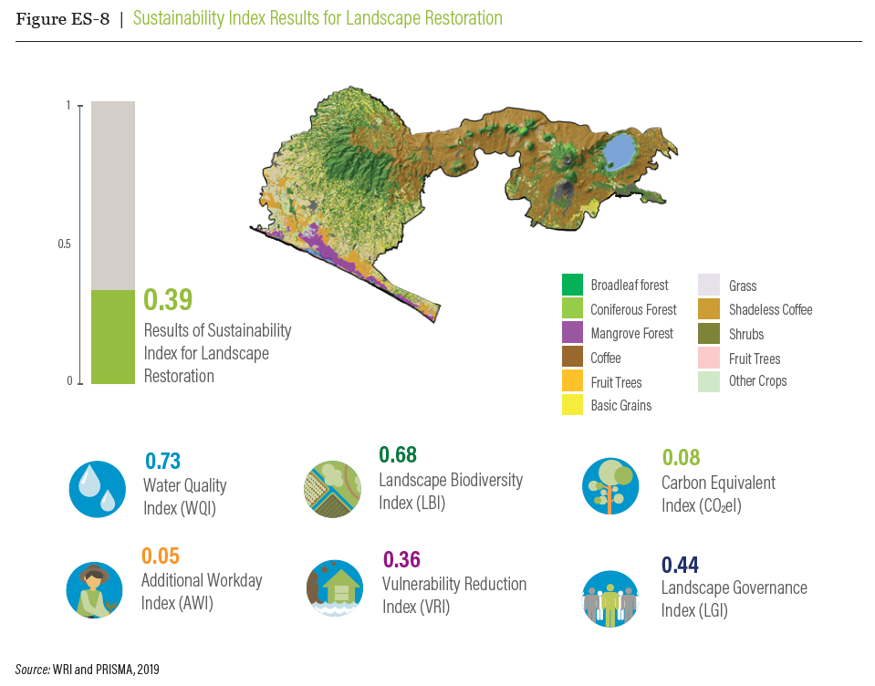
Sustainability Index for Landscape Restoration
This field-tested tool was built from the Road to Restoration guide and created by WRI, PRISMA, GIZ and the Government of El Salvador. It allows governments and project developers to communicate their success by building a Sustainability Index for Landscape Restoration (Figure 5). The index evaluates progress toward the biophysical and social goals that have been set for a given landscape with a simple score (Cristales et al. 2020). The overall score measured by the index can be broken down into various biophysical and socioeconomic components, which allows for a better understanding of the impacts of restoration.
Figure 5. Sustainability Index for Landscape Restoration as applied to El Salvador’s El Imposible-Barra de Santiago landscape. Source: Cristales et al. (2020)
This standardized platform connects projects that grow trees with potential funders — including philanthropists, private companies, and non-governmental organizations — who want to restore degraded land (WRI 2020). After matching funders and projects, TerraMatch collects information on how much funding has been provided to projects (Figure 6). This enables the platform developers at WRI to assess how much finance has flowed and to which type of restoration projects, and TerraMatch is also directly integrating project-level biophysical monitoring.
Figure 6. An overview of the TerraMatch tool. Source: WRI (2020)
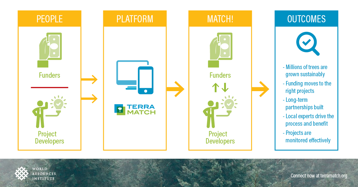
Table 1. Summary of scale, strengths and weaknesses of seven restoration monitoring tools
| Scale | Strengths | Weaknesses |
| Road to Restoration | ||
| Landscape and national levels |
|
|
| Tree Cover Mapping | ||
| Landscape and national levels |
|
|
| Collect Earth | ||
| Landscape, national and regional levels |
|
|
| Collect Earth Online | ||
| Landscape, national and regional levels |
|
|
| Restoration Mapper | ||
| Project, landscape, national and regional levels |
|
|
| Sustainability Index for Landscape Restoration | ||
| Landscape and national levels |
|
|
| TerraMatch | ||
| Project level |
|
|
Restoration monitoring beyond biophysical changes
Assessing physical changes in land use and land cover over time using satellite imagery is the most straightforward indicator of effective restoration. But a robust monitoring system also needs to include other contextual elements, such as these:
-
environmental factors such as biodiversity and climate protection;
-
socioeconomic factors such as food security and access to clean water that will indicate whether restoration has achieved its end goals;
- political will and favourable policy conditions, which signify sustained commitment to restoration; and
- stable financial flows and increased investments, which indicate a willingness to fund longterm work.
The Sustainability Index could effectively aggregate biophysical and socio-economic data to show overall progress, once relevant and available data are collected. Although these dimensions and factors are complex, they are also the basis of successful restoration at scale that will bring positive changes to livelihoods and the environment.
Conclusions
To meet Africa’s potential for restoring land at scale, there is an urgent need for a comprehensive vision for monitoring, built on independent data, that does more than just identify areas that would benefit from restoration. African countries should therefore consider devising monitoring systems that align with their national restoration strategies and that ultimately support the goal of restoring 100 million hectares by 2030. This article highlights existing tools and monitoring frameworks that can guide African countries in the development of their monitoring systems at a range of scales. The monitoring of forest and landscape restoration is still a developing field of study, and the following actions would help project managers and countries develop robust systems:
- Use the Road to Restoration to guide the selection of the main indicators and metrics that reflect local goals.
- Focus on indicators and metrics that people already know how to collect, when reporting on existing commitments or programmes.
- Identify data from sustainable sources; i.e., that can be collected systematically for the foreseeable future.
- Establish the baseline conditions of the land by using tools such as Collect Earth or by extracting information from existing datasets.
- Use the Sustainable Index for Landscape Restoration to aggregate the data collected and present it clearly.
- Monitor changes in indicators and metrics over time and update the index as required.
- Report progress on restoration through national and international platforms such as the Restoration Barometer.
As an AFR100 partner, WRI is continuing to help governments, independent monitors and local organizations to integrate high-quality data into their monitoring work – and to follow the steps outlined above. By building the capacity of local institutions through targeted training, WRI is dedicated to ensuring that restoration data is locally owned and managed. The AFR100 Secretariat could support the mainstreaming of such tools and facilitate their implementation in member countries; this would allow consistent tracking of restoration progress across hundreds of landscapes throughout Africa. Investors and funders need to build the costs of high-quality monitoring into their proposals. Finally, it is crucial to remember that although it is essential to have solid data, innovative tools and robust plans, they will be useless unless people and organizations can act on the results on the ground.
References
Akinnifesi, F.K. 2018. “Africa’s forest landscape restoration gathers momentum.” Nature and Faune 32(1): 3–10.
Brandt, J. and F. Stolle. 2020. A global method to identify trees outside of closed-canopy forests with mediumresolution satellite imagery. ArXiv:2005.08702 [Cs, Eess].
Brink, A.B. and H.D. Eva. 2009. “Monitoring 25 years of land cover change dynamics in Africa: A sample based remote sensing approach.” Applied Geography 29(4): 501–512.
Buckingham, K., S. Ray, C.G. Granizo, L. Toh, F. Stolle, F. Zoveda, K. Reytar, R.Z. Cristales, F. Landsberg, M. Matsumoto and J. Brandt. 2019. The Road to Restoration: A guide to identifying priorities and indicators for monitoring forest and landscape restoration. FAO and WRI. 70 pp.
Chazdon, R.L. 2017. “Landscape restoration, natural regeneration, and the forests of the future.” Annals of the Missouri Botanical Garden 102(2): 251–257.
Cotillon, S. and M. Mathis. 2016. Tree cover mapping tool—documentation and user manual. Open-File Report 2016–1067. U.S. Geological Survey, Reston, Virginia, USA.
Cristales, R.Z., D. Herrador, N. Cuellar, O. Díaz, S. Kandel, J. Quezada, S. de Larios, G. Molina, M. Rivera, M., W.M. Ramírez and A. Jimenez. 2020. Sustainability Index for Landscape Restoration.
Cristales, R., S. Mahamoudou, R. Singh, W. Anderson, P. Ndunda, M. Oliveira, K. Reytar, J. Brandt and M. Matsumoto. 2020. The Road to Restoration: 3 Steps For Transforming Landscapes. World Resources Institute. www.wri.org/blog/2020/10/3-steps-for-land-restoration.
Government of Malawi. 2018. Framework for monitoring progress on Malawi’s national forest landscape restoration strategy. The Ministry of Natural Resources, Energy and Mining, Lilongwe, Malawi. 45 pp. Hanson, C., K. Buckingham, S. DeWitt and L. Laestadius. 2015. The restoration diagnostic: a method for developing forest landscape restoration strategies by rapidly assessing the status of key success factors. Ver. 1.0. WRI, Washington, D.C.
Miyoshi, G.T., M.D.S. Arruda, L.P. Osco, J. Marcato Junior, D.N. Gonçalves, N.N. Imai, A.M.G. Tommaselli, E. Honkavaara and W.N. Gonçalves. 2020. “A Novel Deep Learning Method to Identify Single Tree Species in UAVBased Hyperspectral Images.” Remote Sensing 12(8): 1294.
Reij, C. and D. Garrity. 2016. “Scaling up farmer-managed natural regeneration in Africa to restore degraded landscapes.” Biotropica 48(6): 834–843.
Reytar, K., F. Landsberg, F. Stolle, W. Anderson, J. Brandt and M. Matsumoto. 2020. The challenge of tracking how a trillion trees grow. www.wri.org/blog/2020/07/trillion-trees-tracking-challenges.
Sloan, S. and J.A. Sayer. 2015. “Forest Resources Assessment of 2015 shows positive global trends, but forest loss and degradation persist in poor tropical countries.” Forest Ecology and Management 352: 134–145.
Temperton, V.M., N. Buchmann, E. Buisson, G. Durigan, L. Kazmierczak, M.P. Perring, M. de Sá Dechoum, J.W. Veldman and G.E. Overbeck. 2019. “Step back from the forest and step up to the Bonn Challenge: how a broad ecological perspective can promote successful landscape restoration.” Restoration Ecology 27(4): 705–719.
WRI. 2020. Tracking Progress: Monitoring Forest and Landscape Restoration. www.wri.org/our-work/project/measuring-progress-restoration.